Helston Harbour
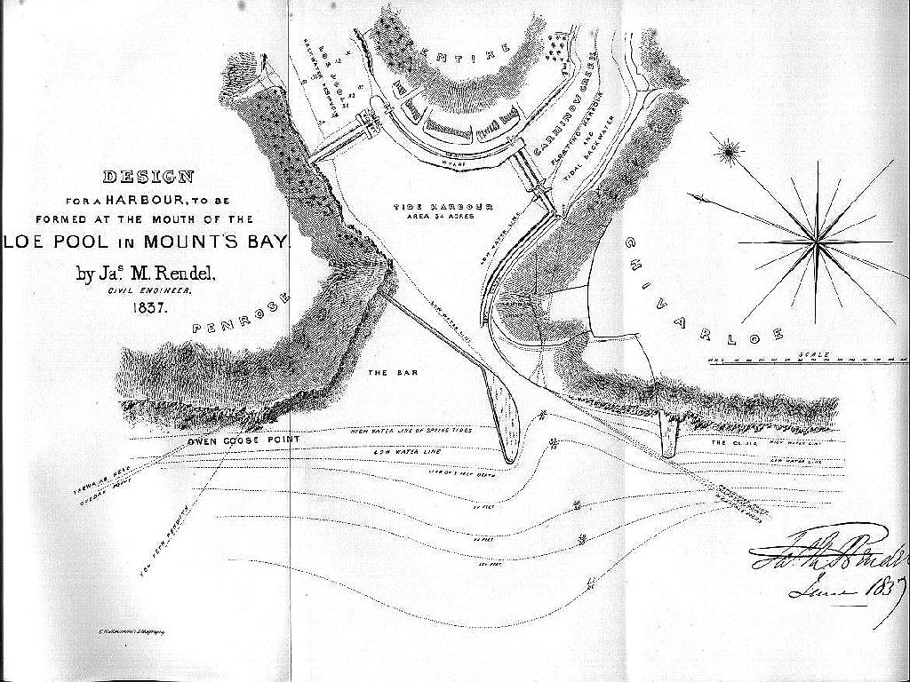
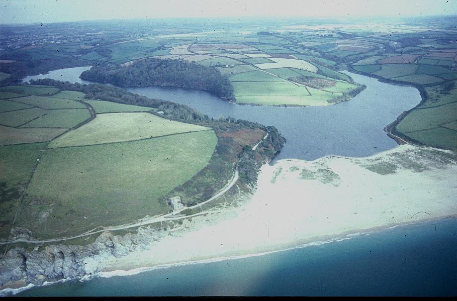
In 1837 a comprehensive plan was drawn in which it was proposed that Loe Pool be developed into a protected harbour by the construction of piers through Loe Bar. If the plan had come to fruition Helston would have developed in a very different manner to what we see today.
Loe Pool & Loe Bar would certainly not be the haven of peace and tranquility that we can all enjoy under the protection of the National Trust and without doubt the fantastic scenery would no longer be in existance.
From a very early age growing up in Helston the whole idea of what might have been built in Loe Pool has intrigued me and having recently discovered a copy of the original letter from the Design Engineer J.M.RENDEL together with the plan taken from Toy`s History of Helston in my late Grandfathers personal papers I have decided to reproduce them on the Helston History Website. I make no apology for the size of this webpage and depth of content as this plan, considering that it was proposed almost 200 years ago, is even by todays geomorphological engineering standards, quite remarkable.
Those of you who wish to see the full scale plan will find it hanging in the Helston Folk Museum.
REPORT ON THE PRACTICABILITY OF FORMING A HARBOUR AT THE MOUTH OF THE LOE POOL IN MOUNT`S BAY , NEAR HELSTON, WITH AN APPENDIX TO THE REPORT, DATED 30th MAY 1837 AND ADDRESSED TO THE REV. CANON ROGERS OF PENROSE, HELSTON
BY J.M.RENDEL OF PLYMOUTH, CIVIL ENGINEER
“Sir,
Agreeably to your instruction, I have examined the Loe Pool, with a view to the formation of a harbour at its mouth in Mount’s Bay, have caused correct Surveys and Plans to be made, have had the Bar examined by borings, and after a careful consideration of every circumstance connected with the enquiry, I beg to submit the accompanying Design, and following Explanatory Report.
The Loe Pool, in its primitive state, was obviously a deep inlet of Mount’s Bay, terminating at Helston, where it formed the Estuary of the small river Cober. Its decay as a harbour would naturally commence with the appearance of the gravel which now forms the beach from Porthleven on the west, to Gunwalloe on the east. This beach from its earliest formation, as at present, would be drifted eastward or westward along the shore, according as the winds prevailed; and in passing the Loe Pool, a portion would be washed into its mouth beyond the general line of coast, and there find a resting place. In this way the Bar would accumulate until it formed a part of the general beach, to the exclusion of the sea, and retention of the Cober with its tributary streams, so as to form a lake. Doubtless the scour produced by the ebb-tide and land waters, acting as an antagonist power, would greatly retard the formation of the Bar. Harbours with mouths much contracted in proportion to the capacity of their interiors, or such as form the embouchures of large rivers, are preserved upon this principle. In the case of the Loe Pool, these conditions did not obtain, its mouth being comparatively capacious, and the river small.
Now it is manifest that in order to maintain an entrance, it will be necessary, (1) to prevent as much as possible the drift of the beach across its mouth; (2) to increase the quantity, or power of the back water; (3) to proportion the size of the entrance thereto.
I have before remarked that the beach is drifted east and west as the wind happens to prevail. For instance, it is found that a continuance of easterly winds reduces the quantity of beach at the Gunwalloe end, and increases it at the Porthleven end, whilst westerly winds do the same thing in the opposite direction.
This reciprocating motion is wholly produced by the waves, or rather breakers, which falling obliquely on the shore in easterly or westerly winds, carry the gravel forward with them until interrupted by the rocks at Porthleven and Gunwalloe, which, projecting into the sea to a depth below the action of the waves, terminate the beach. It is well ascertained that tile action of breakers on the most exposed shores is not felt at a greater depth than ten to twelve feet; we may therefore infer that in the embayed situation of the beach under consideration, the action is not felt at a greater depth than five to six feet. In confirmation of this, we may adduce the fact that several of the smaller beaches along the shores of the Bay retain their distinctive character when separated by the least projection of rocks below low water.
It appears then that in order to stop the beach from entering the harbour’s mouth, it will be necessary to project the entrance piers seaward, into five or six feet of water at low water. Supposing this depth to be constantly maintained, I am quite sure it would be sufficient to stop the progress of the gravel across the entrance. But it must be remembered that the accumulation which will inevitably occur at the back of the piers between high and low water, will have the effect of shallowing the water at their heads; consequently it will be necessary to extend the piers so much farther as will make room for their largest accumulation that can happen, still leaving six feet of water at their heads.
The best guide to a right decision on this point is the accumulation which occurs at Porthleven, etc., but assuming these piers to be built, and consequently the continuity of the present beach destroyed, the accumulation would be reduced in proportion to the respective lengths of the severed parts, and since the piers would be built as nearly as possible midway in the length of the beach, it follows that the end accumulations which would then take place would be reduced in proportion.
Fully according in the opinion that this beach is solely composed of the debris of older cliffs of the same locality, I am prepared to rely confidently on the statements of the old people who live on the coast, that it decreases rather than increases. Indeed, this is a natural consequence, as the trituration which the breakers occasion would be carried out into deep water, and as there is now no accession of materials from the cliff to make up for this waste, the result is the diminution observed.
After due attention to these important facts, I am prepared to recommend that the piers should terminate ten to twelve feet of water at low water Spring tides and have so drawn them on the accompanying design.
The position which the piers should have is the next important point for consideration. In determining this, it must be remembered that we have not only to stop, or collect the beach, but to facilitate its dispersion on a change of wind. It follows, therefore, that the piers should be at right angles to the course of the beach, and I have so designed them.
It will be seen that I propose to form the entrance south-east end of the Bar, or under Carminow Point, which I think best, both in an engineering and nautical point of view.
The Clijer rocks, by their projection, offer a good site for the eastern pier, and I have accordingly adopted it; whilst the western pier is so placed as to cover the harbour from the S.W. winds, and stop the inrun of the sea. The opening between the piers is 1150 feet, a great advantage to vessels entering or departing with a scant wind, and not in danger of being choked, as the gravel once removed would be kept clear by the prevalence of on-shore winds. This, the very opposite of what may be supposed, is produced by the recoil (or undertow, as it is technically called) of the breakers. Urged on by successive elevations, the waves reach the shore with a velocity due to the force of the wind, and being broken and expended, return underneath, or along the bottom, where the resistance is least. The harder, therefore, the wind blows, the stronger this undercurrent will be to restore the equilibrium, and consequently the greater its power to sweep away the gravel and sand. Hence I infer that having once cleared the sand and gravel from that part of the shore included between the piers, the great prevalence of on-shore winds will keep it clear, there being no indraft of water to counteract the undertow.
Supposing rock to have been found at the most favourable level for founding the piers, still difficulties would remain to make their construction in stone exceedingly expensive, but in the absence of rock, stone piers are (if we consider expense), impracticable. I propose therefore to enclose the spaces represented on the Design as occupied by the piers, as well as by the wall extending from the inner end of the western pier to Rogers’ Point, with a double row of piling of the strongest kind driven to a sufficient depth. The piles to be quite close to each other in the front row, but in the back row to be five feet apart, and the distance between the two rows to be fifteen feet. This space I propose to fill with concrete made by a due admixture of the gravel and ground blue Lias lime from a depth of two feet below low water to the top of the piers, or twelve feet above high water.
But to give greater solidity to the pier heads, I propose to make them a solid mass of concrete, as far in-shore as half-tide mark, and to finish the surface of the remaining parts with a floor five feet thick, of the same material. This mode of constructing the piers was suggested to me by the excellence of the gravel and sand found on the spot for making concrete, and from having witnessed lately at Brighton, Woolwich, etc., in works somewhat similarly situated, its successful employment. I know from observation and experience that piling of the kind proposed will last half a century at least, and long before the lapse of that time the concrete would have hardened sufficiently to be independent of its protection. But should it be otherwise, those parts of the piles that would be liable to decay, (viz: between wind and water), might be renewed at a trifling expense.
This is not the place to enter into the detail of the plan of operations for forming the piers; suffice it therefore to say that I have satisfied myself most thoroughly of its practicability and that it is at once the best and most economical mode that can be devised.
It will be seen by the soundings given on the accompanying plan of the Loe Pool that a large quantity of sand will have to be removed from the interior of the proposed harbour, as well as from its entrance. The whole of this might be scoured away by the backwater when the interior works (hereafter described) are finished, but I should recommend its removal by waggons, steam dredging vessels, etc., to some place from which it could not return excepting only that portion which is below low water, and is not sufficient to encumber the roadstead at the entrance, supposing it to be lodged there.
Having described the plan of the entrance and stated the local peculiarities which have influenced me in forming it, I shall proceed with a description of the works for increasing the power of the backwater.
As will be seen on reference to the Designs, I propose to form a dam across the Loe Pool, at north Pentire Point, and another across Carminow Creek near Pentire Farm buildings. In the dam across the Lee Pool, I propose to construct five sluices, and a lock for the passage of vessels, and in that across Carminow Creek, a pair of gates to admit the tide and vessels, if necessary. The Loe Pool within the dam, to be used as a fresh water reservoir, ponded ten feet above high water, whilst the reservoir in Carminow Creek would be for the reception of the tide. By the employment of the sluices in the Loe Pool dam, the whole of the higher parts of the harbour would be kept clear, or scoured to any depth required; by the same operation through the gates of Carminow dam, that portion of the harbour would also be preserved. But in order to have a power adequate to any emergency for keeping the entrance to the harbour clear, I propose to form a canal round Pentire Point with gates for uniting on such occasions the two reservoirs, and another round Carminow Point with sluices opening immediately on the narrow part of the entrance, through which the whole body of water contained in the two reservoirs might be discharged. The Loe Pool reservoir at the pond level would have an area of upwards of one hundred and seventy-one acres, and I have ascertained that the supply of water by the Cober and its tributary streams may be taken on an average for the year at two thousand, three hundred cubic feet per minute. The reservoir in Carminow Creek has an area of upwards of sixteen acres at high water, and at the level of ten feet above, nearly twenty-five acres. By means of these powerful backwaters employed in the way proposed, I am decidedly of opinion that an entrance channel of two hundred feet in width may be kept open to a depth of at least five to seven feet below low water Spring tides, and that by far the largest portion of the harbour, which is upwards of thirty-four acres, might be kept at the same depth.
As an adit would be necessary for the drainage of the Pool during the execution of the works, I propose to form it through Carminow Point, as laid down in the plan, and by finishing it with three branches opening on the mouth of the harbour, as shown, it might afterwards be used in assisting to keep that part of the entrance clear.
I have before stated that a lock is to be placed through the Loe Pool dam for the passage of vessels. I have also stated that the Loe Pool would be ponded ten feet above high water mark, This ponding, as perceived by the section given on the general plan, will cover the whole of the green up to Helston, and by digging a canal twelve feet deep, from near Wheal Pool, under Neloe, up the marshes to Helston, vessels of three hundred tens burthen might be taken to that place. If the laying of the marshes and green under water should be deemed objectionable, the Canal might be formed with banks. A basin should of course be made at the head of the Canal, for which purpose there is a variety of eligible sites, the selection of which may be made independent of the Engineer. In being able to take large vessels up to Helston, there certainly would be a great advantage to the town, and consequently great prospect of remuneration for investment of capital in the harbour.
But there are other advantages in having a large lock through this dam. I fully anticipate that the harbour, formed as before described, would become a place of refuge and a port for wind-bound ships. Vessels of the largest class would be able to enter, and having the advantage of passing into the Loe Pool, and there lying afloat, would unquestionably do so. For the accommodation of smaller vessels, Carminow Creek might occasionally be used as a tidal floating harbour. With such alterations, its situation being the best possible, and its roadstead affording excellent anchorage in from five to eleven fathoms water, I am quite satisfied that this harbour would become the common rendezvous of the Bay, and be found of infinite advantage to the trade of the English Channel, as well as highly important to the neighbourhood of Helston. As a fishing and pilot station, it would possess commanding advantages,as vessels of the class so employed would be able to enter and depart at all times of tide. Should building ground be wanted, as under such circumstances it unquestionably would be, North Pentire Point offers an eligible site, whilst shipwright’s yards, with all the necessary appurtenances for either building or repairing, could be advantageously laid cut on the shores of Carminow Creek.
Hitherto I have said nothing on the subject of interference with the ornamental character of the Pool, or the privacy of Penrose. It is necessary therefore for me, in conclusion, to remark that as regards the beauty of the lake, and preservation of the fish, the proposed ponding would be highly advantageous. As to the privacy of Penrose, I am decidedly of opinion it would be more consulted by the passage of sea-borne vessels up to Helston, than by a transfer of their cargoes into barges at the Port, and the use of them in the Pool. I have ever found that bargemen, from their local connections and numbers, are most addicted to that kind of trespass, objectionable to ornamental property, and I cannot believe that a lover of the picturesque would be more offended by the sight of a vessel under full sail in this romantic lake, than by barges moved along its margin by manual labour. I have studied to keep the harbour, or busy part of the scene, entirely away from the grounds of Penrose, and to remove every objection to its appendages that would not materially interfere with its utility and success. The following estimate of the cost of the works has been prepared with much care in full detail. It will be here sufficient to give the results in aggregates only.
ESTIMATE
Western Pier …………………………………………………………………….£42452 0. 0.
Eastern Pier ……………………………………………………………………..£10075 0. 0.
East Wall at Entrance …………………………………………………………£2550 0. 0.
Excavations ……………………………………………………………………….£16404 0. 0.
Dam, Sluices and lock for thePool ……………………………………….£21067 0. 0.
Canal and Locks, to unite the Loe Pool and Carminow Creek , with Wharves for the accommodation of theHarbour…………………………………………….£11507 0. 0.
Dam and Tide Gates for Carminow Creek………………………………£6773 0. 0.
Canal and Sluices round CarminowPoint……………………………….£7695 0. 0
TOTAL : £118523 0. 0.
In this estimate, I have allowed for all probable contingencies and adopted the present high prices for labour and materials. With reference to the time necessary for the execution of the work, I see can no difficulty in completing it in from three to four years. It will be observed that in general principles, the plan here proposed differs little from the sketch given by Mr. de la Beche, and it is highly gratifying to me to find my own judgment in unison with so scientific and accurate an observer. I have to express my obligations to that gentleman and also to acknowledge valuable information received from Mr. Enys, of Enys, Mr. Plomer of Helston, and the late lamented the Mr. George Borlase
‘I have the honour to be, Sir, Your most obedient servant,
M. RENDEL.
HELSTON HARBOUR
APPENDIX TO THE REPORT
NOTE A.
That the Loe Pool has maintained its present form and condition, from a time of which we have now no record, appears a point allowed by all antiquarians, but that it was once an inlet in which the sea used to ebb and flaw there is every reason for believing, supported as that opinion is by the general voice of tradition. The cliffs observable all round the shores of the Pool, particularly in those parts most exposed to the sea, afford presumptive evidence that something more than the Loe in a storm has been the agent to bring them to their present perpendicular form. Passing over as fabulous the tradition still frequently related in the neighbourhood that the formation of the Bar occupied but one night, I may notice the legend of Tregeagle, which however altered from the original story seems to convey a confused idea of the formation of the Bar by the drifting of the beach eastward and westward across its entrance. The earliest work in which the Loe Pool is mentioned, I believe to be the itinerary of that faithful observer Leland who, writing in the early part of the sixteenth century, says that `1f this Bar might always be kept open, it would form a goodly haven up to Helston’. The Pool and Bar as existing in the tine of Carew are minutely described by him, and it may be remarked that he speaks of the breaking of the Bar as of frequent occurrence, and a work of little labour compared with what we find it to be now. Subsequent accounts agree very nearly with the foregoing and clearly bear out the opinion that the Bar has been formed by a succession of accumulations, as before described.
NOTE B.
With other information obligingly coimnunicated by Mr. Enys, of Enys, the origin of the beach is satisfactorily explained as due to the debris of the cliffs of the same locality. He says:
‘Suppose the land destroyed by common waves, inside a line drawn from Trewavas Head to Gunwalloe Point, a’ la Lyell, or by any other means and the slate mud deposit carried out by the undertow and not returned, the quantity of quartz in the cross courses and in the squats is at least sufficient to form the beach’.
NOTE C.
The very small admixture of sediment or earth with the sand of the Bar is the reason that the water finds such an easy passage through it. The quantity of water running off in this way, when the Loe Pool is at a high level, is very great. The surface was observed during the survey to sink for several successive days by four inches a day, when it was from six to eight feet above high water level. This depth of four inches over the whole surface added to the influx of the river, etc., during the same time, amounts to seven million cubic feet – the quantity lost by filtration in twenty-four hours. The level at which equilibrium is maintained appears to be below high water spring tides. The consequence of the frequent breakings of the Bar, which, as is well known, carries out into the Bay an immense quantity of sand, is that the lines of equal depth are removed in a very regular curve further off from the middle of the Bar than any other part of the shore, as may be seen in the general plan.
NOTE D.
Result of borings in the Bar
The first boring (at A on the Plan) was situated at about four hundred and fifty feet from the foot of the western shore, where the surface of the beach is about twenty feet above high water level. The sand towards the surface contains a larger proportion of coarse gravel than is found at a greater depth, the finer parts having been probably washed away. It also contained throughout more sediment than was found at the subsequent borings from the long time which has elapsed since the Bar was broken there. Several fine and coarse beds were cut through and at fifty feet from the surface occurred a layer of fine silt. The boring was carried down sixty-eight feet or to thirty feet under the low water level, without finding anything indicating the neighbourhood of rock. The second boring was four hundred feet from the opposite shore, the surface of the beach being one hundred and forty-six feet above high water and at the depth of twenty-five feet a bed of silt similar to the former was found, resting on a layer of fine sand, precisely like that spread over the bottom of the Bay. This boring was carried to a depth of fifty-one feet or eighteen and one half under lower water level without reaching rock. At the third boring (C on the plan), distant from Carminow Point one hundred feet, the sand was considerably finer the surface twenty feet above high water, and its depth thirty-seven feet, the rock on which it lies being firm killas.
The fourth boring (D on the plan), was two hundred feet nearer the sea than the last; the rock here is four feet below the level of low water, and is covered with a floor of hard quartz, impenetrable to the boring tools. The fifth boring was situated within No. 3, about the same distance from Carminow Point, nearly on the high water line of the Pool, and was carried down twenty-two feet, the rock at the bottom being two feet under low water. The three last borings were nearly in a direct line across the Bar. In boring a hole in the Weeth Green, where several alternate layers of mud and sand occupied the first fifteen feet in depth, several rotten trees and pieces of wood were cut through. A layer of granite sand about eighteen inches in thickness covered the surface of the killas, which was twenty-eight feet below the level of the surface.
NOTE E.
It is well known that the extreme solidity and durability of many of the architectural works of the ancients were obtained by the use of a concrete, similar to that which has been used with so much success in many otherwise impracticable works in modern times. Among the oldest examples, the walls of the city of Messene, erected 370 B.C. are wholly of this description.
In the remarkable and well-known wall of China, a construction very similar to concreting, was adopted, and notwithstanding numerous vicissitudes, it is still wondrously strong, and exhibits so signs of decay. At Rome there are few remaining monuments in which, either in foundations, in the shape walls, or of pavements, etc., it is not to be found. The temples of Augustus, the baths of Agrippa, of Titus, and Diocletian, the Coliseum, the Aqueducts, St. Peters, the great military roads, and many others serving as instances.
Within the last twenty years, concrete has gradually been making converts among the most eminent Engineers and Architects of our own country and at the present time, it is become so generally approved that there is scarcely a large public work executed where it is not employed, either for foundations or backing of walls, etc. It was first extensively used in building the East India Docks, in re-building part of the penitentiary at Millbank, where the foundations had failed, and with the most complete success in the reconstruction of the foundations of the Custom House. Mr. Telford employed it in the construction of St. Katharine’s new docks. At the Westminster New Bridewell, £30,000 were spent on the foundations which were formed under water as a concrete sub-stratum seven feet thick, not the slightest settlement having since taken place. Still more recently, a wall concrete has been built at Brighton, thirty to fortyfeet high, to keep up the cliff near the Chain Pier, and an extensive sea-wall of the same material is new building at Woolwich Dock Yard, under the sanction of the Lords of the Admiralty. In this latter case, the concrete is prepared in moulds, or cast in square masses and used in the same way as cut stone. It is, however, very questionable if this be so advantageous a mode as using it as in mass. The above cited instances will show how well-suited this method of construction is to the work proposed, which, long before the decay of the wood facing, would be little else than a solid pier of artificial stone.
NOTE F.
The area of the Loe Pool, or reservoir within the backwater dam at the level of high water Spring tides is ninety-one and three quarters acres; at the level of ten feet above high water, one hundred and seventy-one and a half acres. The quantity of water it will contain in every foot of depth between ten feet above and ten feet below high water varies between 4,000,000 and seven million cubic feet, above high water, and approximately four million cubic feet and eight hundred thousand cubic feet below high water.
The quantity from measurements after a fortnight of water flowing into the Lee, I estimate as follows, taken in the early part of the present year (l837), of dry weather.
The quantity of the water brought in by the Cober or Loe River …….. 2,150c.f..
Ditto – Penrose Stream………………………………..…80 c.f.
Ditto – Pengella….………………..……………………..…10 c.f.
Ditto – Penventon……….………………………………….10 c.f.
Ditto – Nelee…………………………………………………30 c.f.
Ditto – Dagibma……………………………………………30 c.f.
Total influx per minute………………………..………….2,310c.f.
Ditto per hour ……………………………………………….138,600 c.f.
Ditto per day ………………………………………………3,326,400 c.f.
Assuming the above as the influx, it will take seven days to raise the surface five feet from the level of high water and nine days more to raise ten feet above the same level. In the above calculation, no allowance is made for increase from surface drainage or and floods, which, from the nature and extent of the surrounding country, would be very considerable, and which of course would be additionally available for the purpose of scouring the harbour.
The area of Carminow Creek, at the level of high water within the backwater dam, is sixteen and a half acres; at ten feet above high water it is twenty-four and a half feet. The cubic contents vary from 755,400 c.f. to 1,102,775 feet above high water and from 278,825 c.f. to 691,125 c.f. above low water.
NOTE G
The Loe frequently rises to the level of the floors of the houses, at the top of the Green now occupied by Mr. Beaglehole and others which are fourteen feet above high water or four feet above the level of the proposed ponding. Its rise is not injurious until it stops the Town Mills, the level of which, with those of the others, I subjoin, by which it appears that neither of them will be injured.
Bottom of wheel of Town Mills……………….12` 10′ above high water.
Ditto – St. John’s Mills……………………………. 14′ .1″ above high water
Ditto – Carminow Mills ……………………………..11′ O” above high water